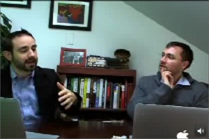
As TechChange and our alumni community continue to grow, we’re sharing the stories of some of our rockstar alumni who have taken the tools they’ve learned and resources from their TechChange courses to make an impact. This week, we traveled to the OpenGov Hub to talk to FrontlineSMS Project Director Trevor Knoblich, who participated in our TC105: Mobiles for International Development course in March-April of 2012. Pursuing his interest in mobile technology in humanitarian response and journalism, Trevor combined his past background with his new connections and knowledge from TC105 to successfully land a job at FrontlineSMS.

Here is Trevor’s story, in his own words.

Why did you decide to take Mobiles for International Development?

Technology in humanitarian assistance was rare in back 2009. Back then, I remember how there was not yet much data sharing and effective data management between aid agencies. As a journalist working in humanitarian response, I became interested in how mobile technology could address various challenges throughout the world. Through my own research, I heard about different projects that involved data mapping and reporting of challenges with service delivery, such as infoasaid, but it was difficult to find a one-stop resource that gave me a good sense of emerging technology in humanitarian work. I wanted to know, what’s happening around the world? What tools are available for me to find out? And what tools are appropriate for my organization?

What was useful to you from TC105?

After doing a search on Google, I found TC105 and immediately enrolled in the course to get an overview of how mobile technology is being applied across international development. I found three key features of TC105 very valuable to me: the relevant information, the interactive experience, and the access to a network of experts in mobile tech.

  1. A central hub for the latest information for mobiles in development. TechChange’s TC105 became a central hub for emerging info and latest applications of mobile technology in the developing world. The TechChange team did a great job at selecting the most relevant and useful information for participants in the course by pulling all types of resources into one space. They included industry reports, real-world and current examples of tools like Magpi and FrontlineSMS, and practical case studies that inspired participants to try the tools out.
  2. Interaction, participation, and global dialogue. The unique interaction built into this TechChange course platform encouraged participation among my classmates. TechChange did a good job of getting participants to talk to each other with game mechanics. I liked the small size of the class that had ongoing global discussion forums (sometimes at 03:00 AM in certain places in the world) and incentives for me to stay actively engaged throughout the entire course. Live demonstrations of the mobile tools discussed in TC105 changed my perception and understanding of how some of those tools were actually used in real life.
  3. Access to a network of industry experts. TechChange invited and vetted an impressive lineup of global experts that presented for TC105. The “Live Event” discussion sessions were especially useful because real practitioners shared their anecdotes of the daily realities they face, and often shared industry resources such as website links and reports that sometimes are not yet on the course syllabus. For example, one of the speakers I remember most was Amy O’Donnell. She was representing FrontlineSMS and was extremely knowledgeable about community radio. In her discussion, she shared research papers and industry knowledge on best practices in the mobile tech space. Beyond these live video conference discussions, TechChange is always pushing for face to face connections when they can through alumni happy hours and a general open door policy.

How did TC105 ultimately impact you and your career?

Taking TC105 ended up being a smart career move. By keeping in touch with Amy O’Donnell, with whom I shared a common communications-oriented background, I eventually landed a job at FrontlineSMS as Project Director for the Knight Media Project. In this role, I manage grants and program design by connecting journalists with FrontlineSMS mobile technology for data management. It’s inspiring work, as I help journalists coordinate their staff, freelancers and citizen journalists, as well as reach out to a broader audience.

Advice from Trevor for taking TC105:

  1. Leverage TC105 within your own organization. If you’re advocating for your organization to adopt these new mobile tools and applications, you will have a variety of useful materials from TC105 to help make your case.
  2. Take TC105 first. Before taking any of the 200 or 300 level courses, TC105 gives you a good overview of emerging mobile technology and will help guide your selection for a deeper dive specific applications of mobile phones..
  3. Participate as much as you can. You’ll ultimately get more out of the course the more engaged you are with your classmates, the professionals who are presenting, and the TechChange staff.

About Trevor

Trevor joined FrontlineSMS in June 2012, and leads FrontlineSMS’ Knight Media Project. Prior to joining FrontlineSMS, Trevor worked as a humanitarian response coordinator with Lutheran World Relief, developing practices and protocols for emergency response in developing countries. His experience includes developing mapping and tracking systems for deployment of humanitarian aid.  Before that, Trevor worked as a federal policy reporter in Washington, DC. His role allows him to combine his skills and experience in both international development and journalism. You can find him on Twitter @mobiletrevor.

To enroll in the next TC105 session, please click here.

With high expectations for mobile health initiatives, and a proliferation of pilot projects (see this map from Uganda), it can be easy to forget that the mHealth field is still young. Like any emergent industry, mHealth is currently experiencing growing pains, a few of which were highlighted by Tina Rosenberg in her recent New York Times article, “The Benefits of Mobile Health, On Hold”.

In the article, Rosenberg raises a number of important points. She cites, for example, the misalignment between expectations and current realities in mHealth:

“Roughly a decade after the start of mHealth, as the mobile health field has come to be known, these expectations are far from being met.  The delivery system is there.  But we don’t yet know what to deliver.”

She also highlights the pilot fatigue that has stricken mobile-saturated countries such as Uganda and South Africa, as both public and private sector actors rush to become first-movers in the mHealth space. In some cases this has led to lack of coordination and limited impact.

But there is a silver lining. New research is underway in the mHealth space, and leading actors in are learning from past mistakes to design more effective platforms. Projects such as UNICEF’s Project Mwana have successfully introduced simplicity to a complex health system. And stakeholders are beginning to wake up to the fact that technology is only one part (and often the easiest part) of the equation.

This issue was addressed by Patricia Mechael, executive director of the mHealth Alliance, in the NY Times article: “We can get excited about the shiny new object, but the real impact comes from thinking about the cultural and professional context in which it’s being implemented.” How are mHealth platforms adapting to new realities, and reacting to emergent challenges?

This will be a key point of discussion in our upcoming Mobile Phones for Public Health online certificate course, in which Mechael will speak as a guest expert. The course, which begins next week and runs from June 3 to June 28, already has participants signed up from over 25 countries.

Through case studies, guest expert interviews, multimedia tutorials, interactive exercises and live demonstrations of mHealth tools, the course will showcase how mobile technologies are revolutionizing global health systems – and how various challenges can be overcome. While current mHealth projects may not yet be meeting lofty expectations, they are certainly moving in the right direction.

For even more information about the course, visit the course page or take a look at the syllabus. To make sure you get a seat, fill out an application here and enroll today!

This past Thursday and Friday (May 8 & 9) I participated in the ICTs and Violence Prevention workshop hosted by the World Bank’s Social Development Office.  We had an excellent collection of experts from across academia, NGOs, and government who discussed the complexities of using technology for violence prevention.  One of the key takeaways from the event was the analytic challenge of identifying where violence was likely to happen and how to encourage rapid response.

The problem of preventing violence centers of two things; predicting where violence will occur and the ability for institutions to respond.  Emmanuel Letouze, Patrick Meier and Patrick Vinck lay this problem out in their chapter on big data in the recent IPI/UDNP/USAID publication on ICTs for violence prevention.  They point out that instead of using big data to aid interventions by large institutions, that big data can be analyzed and packaged so that local actors can use it to respond immediately when they see signs of tension.  I used this model in my talk on crowdsourcing; the goal is for the big organizations to leverage their processing and analytic capacity to produce data that can be used by local actors to respond to tension and threats of violence themselves.

What made the discussion around this challenge so interesting was that the speakers and audience were able to focus not just on the technology, but also on the ways that different cultures understand information and space.  Matthew Pritchard of McGill University gave a fantastic talk about the challenges of mapping land tenure claims in Liberia, since people expressed land ownership in different ways.  He explained that GIS mapping could contain the data on how people understand their relationship to the land – maps layers could have MP3 recordings of oral history, photos of past use, and graphical demonstrations of where borders were.  Finding ways to move beyond external perceptions of local conflict drivers was one of the goals of the discussions, and integrating technology and social science more effectively is increasingly going to be a way to achieve that goal.

This event was also bittersweet for me, since it was my last time officially representing TechChange as their Director of Conflict Management and Peacebuilding.  Starting May 9, I will be joining Mobile Accord as GeoPoll’s Research Coordinator.  After over two years working with Nick Martin and the team at TechChange, I’ve decided it’s time to focus more on data and analytics in the ICT for development space.  While I’m excited for this new challenge, I’ll miss working in the loft where I’ve learned almost everything I know about ICT4D and tech for conflict management.  I wouldn’t be where I am academically or professionally without the insights and support of the colleagues and friends I’ve made at TechChange.  While I’m looking forward to joining the team and GeoPoll, I’ll always be excited to check the blog or cruise by the office to see what amazing new animation or interactive learning platform Will Chester and the TechChange team have conjured up!

We’re excited to partner with the mHealth Alliance yet again to offer our Mobile Phones for Public Health for open enrollment. And we think it matters: When it comes to IC4D (or M4D) projects, even the best technology is often not as helpful as the latest best practices. Patty Mechael, the Executive Director of the mHealth Alliance, was recently quoted in an NYT article about lessons learned from the past ten years of “mobile phones for public health” concluded:

“The tech is only as good as the people it is connecting or system it’s connected to,” Mechael said. ”We can get excited about the shiny new object, but the real impact comes from thinking about the cultural and professional context in which it’s being implemented.”

That same article cast a skeptical eye on the impact of many mHealth programs to date, but singled out Project Mwana as being successful on a large scale in Zambia and Malawi for testing babies of H.I.V.-positive women. When asked to describe what makes Mwana work, Erica Kochi, the co-leader of tech innovation for UNICEF (and confirmed speaker in our upcoming course) described: “Incredible simplicity….It’s not trying to replace the health information system.  For its users, it makes things easier rather than adding more

Nick Martin interviewing Merrick Schaefer

mHealth Interview with Merrick Schaefer on Project Mwana

complexity to an already difficult, challenging health system.”

But mHealth solutions aren’t as simple as scaling successful programs irrespective of context. It requires creating an ongoing dialogue between public health professionals, the medical community, technologists, and government funders.

To that end, we’ve attempted to not just build a successful-project showcase, but a conversation that includes the following speakers and organizations:

  • Robert Fabricant, Frog Design
  • Gustav Praekelt, Praekelt Foundation
  • Alain Labrique, JHU University
  • Sarah Emerson, Center for Disease Control Tanzania
  • Erika Cochi, UNICEF Innovation
  • Yaw Anokwa, Nafundi
  • Martin Were, Regenstrief Institute; Hamish Fraser, Partners in Health
  • Armstrong Takang, Federal Ministry of Health
  • Kirsten Gagnaire, MAMA Global
  • Lesley-Anne Long, mPowering Frontline Workers; Sandhya Rao, USAID

Class starts June 3rd. Visit the mHealth course page to apply and reserve your spot today. Seats are filling up quickly. We hope that you’ll join the conversation!

On February 26, USAID received the “Best Government Policy for Mobile Development” award at GSMA’s Mobile World Congress 2013. And while the Mobile Solutions team was receiving an award in Barcelona, TechChange and the MS team were also receiving over 1,500 mobile poll responses from recipients in DRC taking part in an online exercise designed by 173 USAID staff and implementing partners in 21 countries. The way this was possible is through harnessing the same potential for public-private partnerships used for external implementation and applying it to internal education and collaboration at USAID.


Fig. 1: MapBox visualization of GeoPoll responses.

The exercise was part of a 4-week online course in Mobile Data Solutions designed to provide a highly interactive training session for USAID mission staff and its implementing partners to share best practices, engage with prominent technologists, and get their hands on the latest tool. Rather than simply simulating mobile data tools, USAID staff ran a live exercise in DRC where they came up with 10 questions, target regions, and desired audience. The intent was to not teach a tool-centric approach, but instead begin with a tech-enabled approach to project design and implementation, with an understanding of mobile data for analysis, visualization, and sharing.


Fig. 2: Student locations for TC311 class.

This would have been a formidable exercise for any organization, but fortunately we augmented USAID’s development capacity with the abilities of three organizations. TechChange provided the online learning space, facilitation, and interactive discussions. GeoPoll ran the survey itself using their custom mobile polling tool. And MapBox provided the analysis and visualization needed to turn massive data into a simple and attractive interface. (Want to check out the data for yourself? Check out the raw data Google Spreadsheet from GeoPoll!)

But while the creation of an interactive online workshop for small-group interaction requires barriers to scale, the content is under no such restrictions. One of the videos from our previous course on Accelerating Mobile Money provided an animated history of M-PESA, the successful mobile money transfer program in Kenya, which allows everything mobile phone users to pay for everything from school fees to utility bills and is proving transformative in cases such as Haiti.


Fig. 3: M-Pesa animation used for TC311 and USAID Video of the Week

But there’s still plenty of work to do. As mobile phones continue their spread to ubiquity, the challenges for applying their potential to development will only increase, along with the continuing possibilities as the technology continues to improve. However, in the short term, we’re focused on increasing mobile access, which is the topic of our next course. If you work at USAID or with an implementing partner, we hope that you’ll consider joining us and lending your voice to this process.

THE FUTURE IS HERE! But why is it so hard to apply technology to development challenges in the field? This video with Laura Walker Hudson of Social Impact Lab explores this question in more depth, with topics including:

  • Getting harried aid workers thinking about new ways of doing things.
  • Making technology work in broader contexts, more sustainably, and aiming for quality outcomes.
  • Managing the transition from “pilotisis” to “scale-up fever.”
  • Understanding barriers to progress at an organizational level.

But don’t take our word for it. Check out the video below:

Developed in partnership with the Social Impact Lab Foundation, AES, and PROFOR, this is the second animated video that we’ve done with Laura Walker Hudson (The first was The Power of SMS and Social Change).

If you’re interested in learning more about how we approach animating, check out our blog post: TechChange Animates! How We Turn Your Ideas into Videos. We’re also adding this video to our TechChange Media Library, where you can find our other instructional videos and content.

As always, we’d love your thoughts, so please feel free to leave a comment below or tweet @TechChange. Thanks!

This is a guest post by Matt McNabb, Principal of Caerus Associates. If you are interested in using mapping for digital organizing, consider taking our course Digital Organizing and Open Government. 


Today, my colleagues at Caerus Associates and I are able to announce the BETA launch of a new tool that helps businesses, NGOs, and governments collect, visualize, and share geospatial data in less developed emerging markets. We call it, CaerusGEO.

Geospatial in the Last Mile

The premise is simple. How can we leverage the cloud to deliver geospatial analysis to non-GIS users most familiar with basic, paper based workflows?

In our experience, most businesses, government institutions, and organizations in frontier markets rarely use technology across the enterprise. In some cases it’s a cost issue, in others it’s social stigma related.  But whatever the reason, ICTs are often used simply to support manual, tabular processes that already exist.

Want to run a survey? Use Word, Excel, and printer.

When it comes to spatial data, this challenge is only magnified. Collecting geospatial information can be hard enough, visualizing and sharing it can be even harder. As a result, geospatial information is often relegated to the expert user.  Of course, the GIS industry as a whole is trending towards accessibility, but rarely is it truly meaningful for most enterprises in less developed markets that simply want to know where things happen.

This is what got me interested in a tool widely used within the humanitarian response community called Walking Papers. The value proposition of Walking Papers has been that it extends geospatial data collection to pen and paper. Print off a map, mark it up, then convert what’s written into geospatial data. No magic. No optical character recognition. Just a simple paper insert that allows people without GIS units to collect spatial information in a way that could be easily geo-rectified.

The problem with Walking Papers is that it offers little back to the data collector. There is no visualization or data management. In fact, it’s really only a lightweight tool that lets the user print off a map and, through some gymnastics, let’s her then use it to edit a basemap on Open Street Map. It offers nothing for the non-technical user simply interested in using paper to collect information about events, or perceptions, or whatever other kinds of information one might be interested in seeing over the basemap.

For the past year, we’ve been wondering what it would take to create a tool that filled this gap. Let normal users capture geospatial data in paper formats and return analytical value once collected.

How It Works

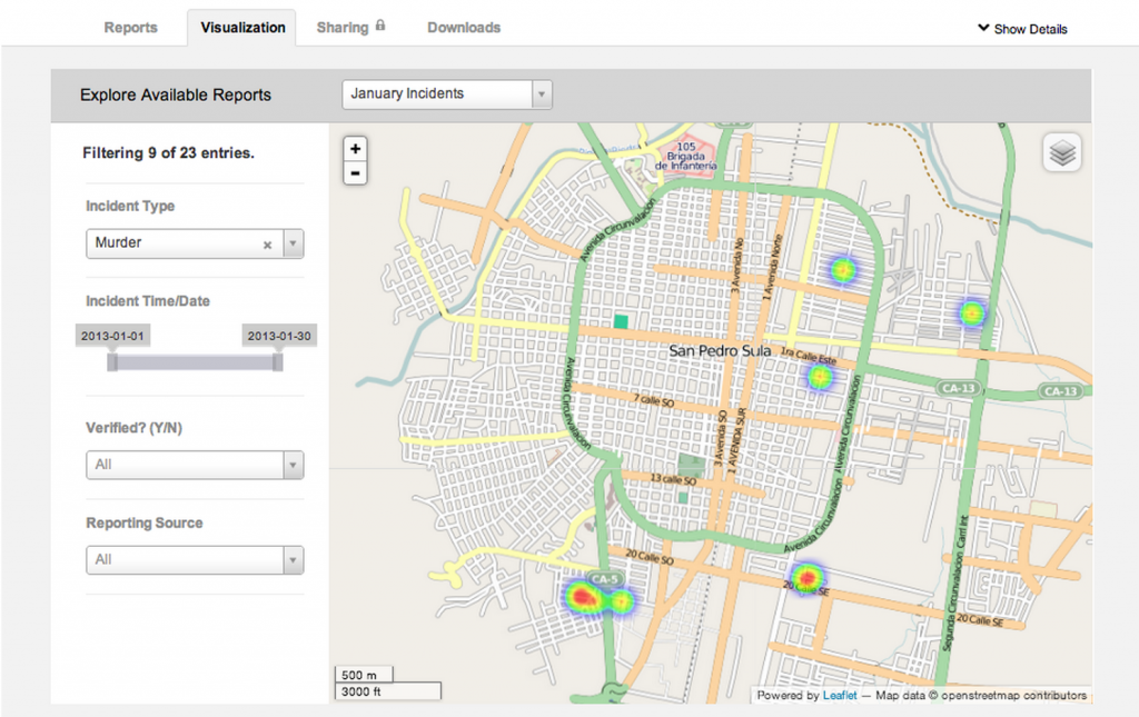
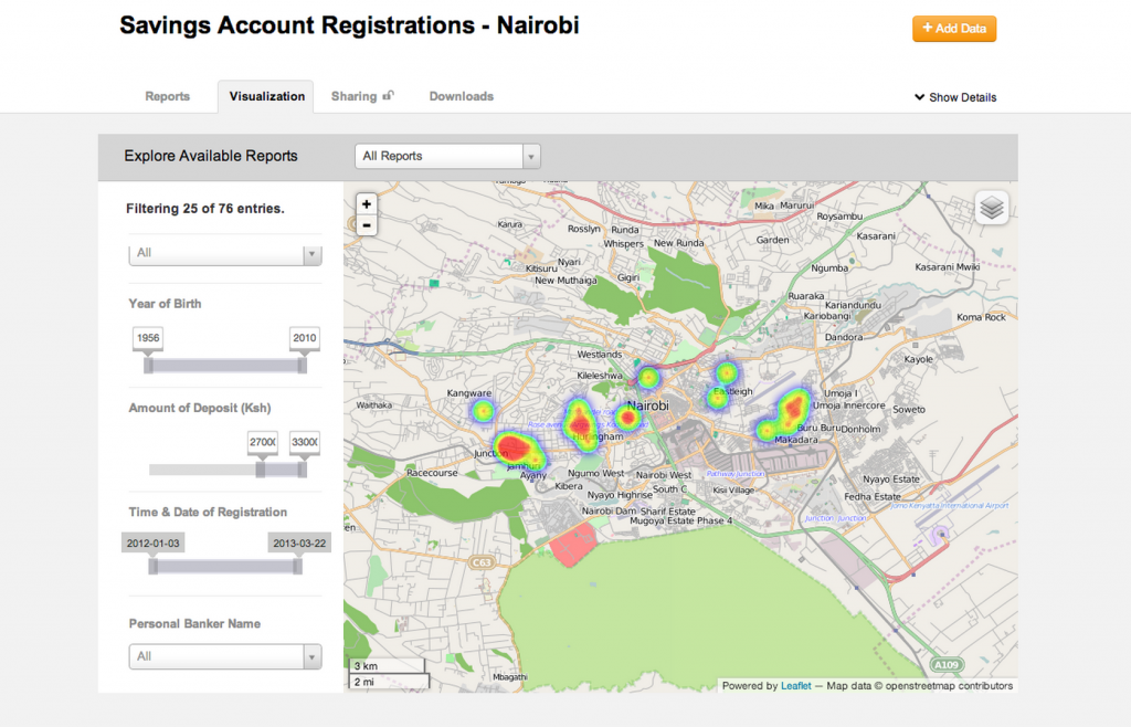
This BETA of CaerusGEO is our first answer to this need. A user is able to create her own survey, find a place in the world where it will be centered, create an atlas and data collection sheets through a standard schema they created, and then manage, visualize, and share the data once uploaded. By bridging cloud analytics to paper workflows, we are able to drive value at enterprise level.

If you’re an NGO and want to integrate mapping into your polling, you can create a survey, manage the data, and facilitate sharing from start to finish. If you’re a business looking to understand your market, you can integrate it into your customer registration process and benefit from basic market intelligence. Although basic in form, the value is derived from a more reality-based understanding of workflows in these markets. Paper matters.

Smarter Public Safety

The very first place we thought to experiment was in the domain of public safety. What could be more obvious than the need for taking those antiquated paper and pushpin constructions used for crude crime mapping and making it more dynamic, analytical, and transparent?

As the Deputy Minister of Justice in Monrovia told me, ‘we send the police where the people are, not where the crimes are… this could help us see how to use our resources in a smart way.’ We can address this challenge by finding minimally intrusive places to insert paper maps into the pre-existing workflows of policing institutions and fusing them together for digital analytics by a single node with connectivity to the cloud.

In parallel, NGOs and violence observatories have the capacity to collect and share their own data, creating a basic framework opportunity for enhancing social accountability within the security sector domain. Perhaps most interestingly, by integrating paper-based mapping that connects to real geospatial data, the longstanding art of Participatory GIS in conflict management and of Crime Prevention Through Environmental Design can be used in so many more ways.

Driving Value For The Private Sector

Public safety institutions are not the only ones we have learned can find value here. It’s also a pull for private sector development, particularly in the bottom of the pyramid. Microfinance institutions and others engaged in understanding their customer base face similar challenges.

By extending geospatial data capabilities to private sector development institutions and retail organizations, we have the prospect of significantly improving the precision and reach of private sector particularly to underserved areas.

So Much To Learn

Bending ICTs to the real-world challenges and workflows found in the last mile holds tremendous value to public and private sector institutions alike. For us, this experiment with geospatial information is only the beginning. We hope you’ll join us and give us feedback as our experiment moves on.

Matt McNabb is a member of the Board of Advisors for TechChange, and a Principal with Caerus Associates. For more, you can follow Matt and CaerusGEO on Twitter:  @mattrmcnabb  @caerusgeo


Interested in learning about Mobile Phones for Public Health? Class starts on June 3! Apply Now.

Mobile devices are quickly becoming much more than just a means to make a voice call. Top of the line devices are now being tested for their ability to be the brains for satellites. But perhaps more important than their capabilities is that they are the most rapidly disseminating technology in human history. Soon only a tiny minority will lack an always on link to the network. What’s more astounding is that this graphic is five years old and currently there are 6 billion mobile phone subscriptions, though duplicates reduce the number of users.

This ubiquity is going to have an unparalleled impact on how just about every facet of social organization operates. The next generation is growing up with an intuitive grasp of making the most of their new technical assistants, and they will incorporate them into new workflows for organizations that are unthinkable at the moment.

The complement to price decreases that are resulting in such tremendous uptake is the exponential increase in capabilities in even the simplest devices. More and more devices are benefiting from applications that enable them to collect data, profit from information services designed to be accessed via SMS or WAP, and increasingly connect directly to the internet over wireless broadband networks. The addition of GPS radios and cameras drastically improves the ability to verify information collected with these devices.

Soon regardless of where in the world you are, you’ll only be a few miles–at the most!–from the nearest node of our globally connected culture.

Interested in learning about Mobile Phones for International Development? Early bird registration for our next class ends on February 25, 2013! Apply Now.

Last week, the Stanford Social Innovation Review (SSIR) published an article by Linda Raftree and TechChange Founder Nick Martin about challenges we saw upcoming in this field around mobile education (What’s Holding Back Mobile Phones for Education? (2/11/2013)).  But last week also marked the announcement of the winners for The Tech Challenge for Atrocity on “Capture.” What both of these events have in common is that they are entirely about the possibility of mobile phones to address global challenges.

According to the website, the Tech Challenge “sought new and innovative ways to enable the documentation of relevant evidence that may be used to deter or hold perpetrators accountable, while minimizing the risk posed to those collecting this information. These winning submissions were chosen on the basis of impact, innovation, scalability and feasibility.” Not surprisingly, the top three awards all went to mobile applications: MediCapt, Silent Lens, and International Evidence Locker.

If you haven’t learned about these innovative projects, we recommend that you head over to the USAID Blog or Humanity United and check them out. In particular, we’d like to congratulate our partners and friends on the Magpi team for their role in InformaCam, which claimed first prize in partnership with Physicians for Human Rights and InformaCam for developing MediCapt. According to Humanity United blog, “[t]his mobile app will equip doctors and nurses with critical tools for collecting, documenting and preserving court-admissible forensic evidence of mass atrocities including sexual violence and torture.”

But while these exciting tools promise new capabilities in atrocity prevention, the SSIR article we wrote also cautions not to take a tech-centric approach to problem solving. The success these tools will have once they are out of development don’t just depend on the latest features, but being in the hands of those who can skillfully apply their potential to the problems at hand. Sooner or later, all technology problems become education problems.

Shameless plug: For those who are unfamiliar with Magpi, please check out our blog post on Goodbye Episurveyor: Hello Magpi!, which lays out more detail on this tool. Or you can check out our video below:

Interested in our upcoming course: Technology for Conflict Management and Peacebuilding? Our next class starts Monday, February 18th. Apply today!

This week, Ushahidi announced the launch of the Uchaguzi partnership in preparation for the upcoming March 4th Kenya elections with the aim “to help Kenya have a free, fair, peaceful, and credible general election.” This announcement came after the Standby Task Force (SBTF) sent an email on February 8th informing their community of voluntary crowdmappers that the SBTF has withdrawn from Ushahidi’s map for not meeting their criteria for activation, but still encouraged their community to participate as individuals. The announcement surprised some in the Standby Task Force community, which had been preparing for deployment, but was not entirely unexpected after the SBTF’s decision to focus on deploying to “natural” disasters after their experience in Syria. The official email explained that:

“The things that we use to ensure that the security, ethics and neutrality that the SBTF stands for is protected, that there is a feedback loop (a physical, on-the-ground response to the data processed by Mapsters) and that we do no harm, e.g. we don’t damage existing in-country responses.”

The notion that external support could be counter-productive is an issue worth considering for the voluntary technical community of peacebuilders. The rise of both local crowdmapping and the global volunteer and technical communities have grown together over the past five years after the violence stemming from the last Kenyan elections gave rise to the Ushahidi platform and the Haiti earthquake saw the development of a global volunteer networks to apply them. Since that time, it’s become clear that the ethical questions surrounding application of technology to peacebuilding are as complex as ensuring technical capability, if not more so.

The challenge of protecting the privacy and security of citizen users is constantly grappled with by the organizations responsible for these tools. The upcoming Kenyan election offers a unique case to take stock of where we stand and where we are moving. Which is why it will form the basis for an activation simulation in TC109: Technology for Conflict Management and Peacebuilding. As part of the activity, we’ll be talking with Justine MacKinnon of the Standby Task Force and Rob Baker of Ushahidi. To understand more thoroughly the opportunities for new technologies to empower peacebuilders.

Of course the ethical impact of new technology is not limited to crowdsourcing, which is why we’re also going to discuss the full spectrum of issues in TC109, from using drones to protect human rights with Mark Hanis to using MapBox to display drone strikes on Pakistan in real-time. New technology often presents as many problems as it solves, and application of even the most potentially beneficial new tools without sufficient forethought can always cause more harm than good.

Class starts on Monday. We hope to see you there! Please feel free to tweet @techchange if you have any questions or send us an email: info [at] techchange.org.