As Syria’s civil war draws close to its third anniversary, actionable data for foreign aid workers remains scarce. Although the conflict has seen the birth of civilian reporting agencies (warning, graphic content) which have uploaded more YouTube videos than CBS News, CNN, Fox News, ABC News and the Associated Press combined, basic questions about where humanitarian aid is most needed and which delivery routes are safest remain unanswered.
It was this lack of information that drew Caerus Associates to partner with First Mile Geo to research opinions about living conditions, safety, and resource access from residents in Aleppo, Syria. Formerly the source of 35% of Syria’s manufactured goods, Aleppo has become a major conduit for humanitarian aid crossing the border to Syria from Turkey. Working with teams based on the ground in Syria, Caerus Associates and First Mile Geo were able to obtain essential data from each of Aleppo’s 56 neighborhoods. The study represents the single most detailed project conducted on the Syrian conflict, showing time-series data with neighborhood-by-neighborhood results over a period of four months.
Field teams conducted bi-weekly data collections on the locations of roughly 180 security checkpoints, as well as the conditions of bakeries throughout the city. Field teams also collected data about political perceptions, service access, and the presence of key groups on a monthly basis. The result is a collection of highly detailed maps that show everything from the price of bread in a neighborhood to the presence of armed groups. Of course, maps and data need to be accompanied by analysis and context, which are provided in an accompanying report that shares just a few of the following key findings:
-
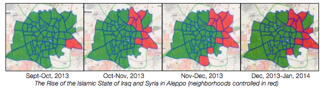
The Islamic State of Iraq and Syria (ISIS), an Al-Qaeda affiliated group is taking over Aleppo. While ISIS was a marginal player, controlling only one neighborhood in September of 2013, it now controls 10 neighborhoods – more than any other than any other armed opposition group in Aleppo. ISIS’ reputation for kidnapping aid workers and disrupting humanitarian operations make the neighborhoods it occupies in the east of Aleppo particularly dangerous to access.
-
The Syrian Government may be actively restricting basic services to opposition-held neighborhoods in Aleppo. Residents who participated in surveys conducted with First Mile Geo reported an average of 6 hours per day of electricity in opposition-held neighborhoods, while those living in government-held areas reported an average of 12 hours per day. Additionally, more than 40% of bakeries – a key source of food in opposition-held Aleppo are closed compared to just 10% of bakeries in government-held areas. The study confirms what many in the humanitarian-aid communities have feared since the beginning of the conflict: the most inaccessible areas of Aleppo are also the ones most in need of humanitarian assistance.
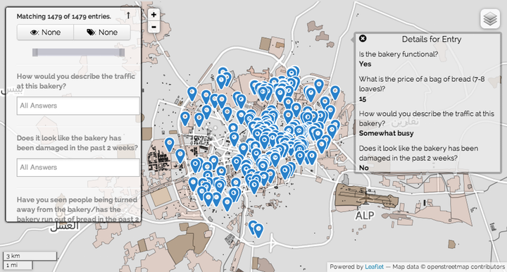
First Mile Geo worked with organizers on the ground in Aleppo to survey which bakeries (bread that bakeries produces is a staple food in Aleppo) were still functional.
-
Lastly, there is little consensus among Aleppines regarding who is the legitimate representative of Syrians. While the just 12% of Syrians felt that the Assad regime was legitimate, less than 2% of the participants said that the Syrian opposition (the “Etilaf”) represented the Syrian people. The majority of Syrians felt that “No One” represented them. Most importantly, these opinions were held evenly across all neighborhoods and did not correlate with whether whether or not a resident lived in a government or opposition-held area. Without a strong mandate from the Syrian people, it’s unclear what (if any) influence is wielded by parties negotiating for peace in Geneva.
Beyond providing key insights about realities on the ground in Aleppo, this study also highlights the importance of geographically oriented information. Even within the geography of one city, the disparities between basic services and safety can vary dramatically between neighborhoods and even city blocks. As developing countries continue to urbanize at a rapid pace, geographic methods such as those used by First Mile Geo will continue to grow in importance for humanitarian organizations looking vulnerable populations.
Interested in digital mapping of Syria or other challenging contexts in international development? Sign up now for our upcoming Mapping for International Development online course which runs May 26 – June 20, 2014. Would you like to access First Mile Geo’s data for your own use? Read their blog post to learn more.