Internet connectivity is increasingly being seen as a human right in our digital world. Today, most of us can’t imagine a world without the Internet, yet only 30% of the world has access to it. Meanwhile, over 85% of the world has cellular coverage and as mobile phones and smartphones become increasingly cheaper, more people are able to access the Internet.

Here are some global initiatives to make the Internet more affordable and accessible to the most remote areas of the world:

1. Facebook’s Internet.org

At the end of August 2013, Mark Zuckerberg introduced Internet.org, a collaborative effort of Facebook, Ericsson, MediaTek, Nokia, Opera, Qualcomm and Samsung to bring internet access to the two-thirds of the world that are still offline.

Recently, Facebook launched the Internet.org app to Airtel customers in Zambia. The app provides access to 13 basic services without data charges; some of the free services include MAMA (Mobile Alliance for Maternal Action), AccuWeather, and WRAPP (Women’s Rights App). Serving as a channel to women’s right resources, Internet.org has received praise from Executive Director of UN Women, Dr. Phumzile Mlambo-Ngcuka as she said that, “This technology will empower countless women to make a positive impact on their societies and the world.” While the full benefit of internet.org is yet to unfold, it is definitely a step forward in allowing women access to much needed services.

2. Google’s Project Loon

Google’s Project Loon pilot project in New Zealand

Starting with a pilot project in New Zealand in June 2013, Project Loon is Google’s initiative to provide “balloon-powered internet for everyone.” Loon balloons float on the stratosphere and rise and descend with wind patterns to their desired direction of travel, while special antennas in people’s homes allow them to connect with the Loon network for online access. In 2014, Project Loon aims to continue their effort to make internet access possible for hard to reach areas by establishing a ring of connectivity of multiple loons around the 40th parallel.

3. BRCK

BRCK

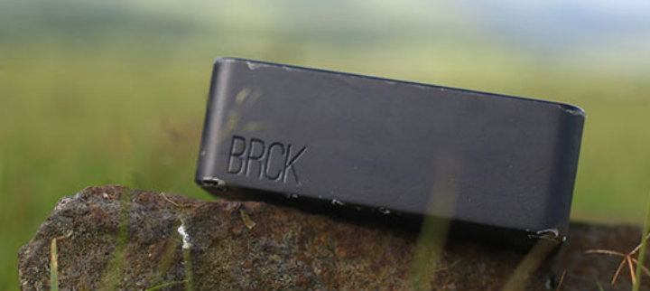
From the makers of Ushahidi, Crowdmap, and the iHub in Kenya, comes BRCK, a $199 connectivity device designed for use in areas with minimal electricity and internet connections. Built to perform in off-the-grid areas, BRCK works with any 3G enabled SIM card in over 140 countries, has a virtual mobile network operator (vMNO) for connectivity without a SIM card, and also has an external GSM antenna port to support connectivity. Designed by the developing world, for the developing world, BRCK claims that “if it works in Africa, it will work anywhere.”

4. Oluvus

Oluvus

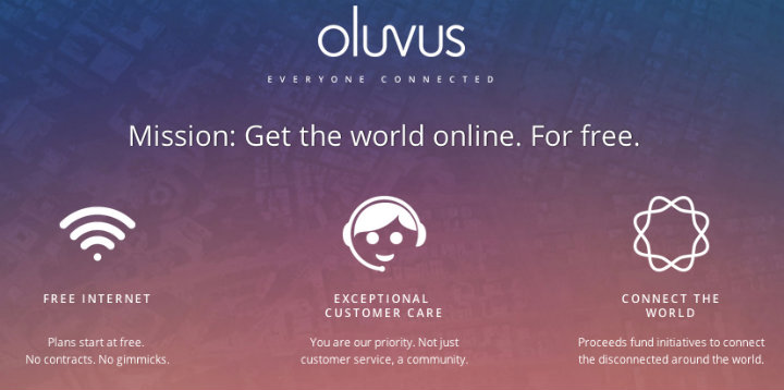
With a mission to “get the world online for free,” Kosta Grammatis is following the footsteps of Facebook and Google in the race to provide free internet connectivity.  Set to launch later this year, Oluvus plans to provide basic internet services for free in the U.S. and use the profit from additional services purchased by their customers to fund connectivity projects in the developing world. Oluvus’s first project is set to take place in the world largest refugee camp, Dadaab Refugee camp in Kenya.


What’s next for internet expansion?

As tech giants Facebook and Google tackle the global lack of internet access, they are sure to be ahead of the game. While Facebook’s internet.org’s success is too early to tell, Google commemorated a successful 120-day afloat of one of their Loon balloons on 7th August proving they can withstand harsh weather conditions. Google and Facebook are also expanding their internet initiatives considering drones and satellites to deliver the Internet to more people.

Critics have questioned the end goal of the various internet initiatives that are emerging, labeling them as “gateway drugs” to their product among the unreached population. Despite the critique, the pursuit to provide internet access to the world combined with the power of internet connectivity to change people’s lives cannot be denied.

Challenges lie ahead for these internet initiatives as they deal with regulatory issues such as spectrum/net neutrality as the U.S. Federal Communications Commission (FCC) has been criticized for trying to regulate. Google’s Loon project may face challenges controlling air traffic for its string of loon balloons and BRCK’s may not withstand all crises while claiming to be crisis-friendly. Those unable to afford computers, laptops, or tablets, are able to leapfrog technology to use mobile phones to access the Internet, making it increasingly empowering in the developing world. The future for internet initiatives looks bright as more businesses and organizations look to reach new customers online by providing internet access worldwide.

Where do you think these internet initiatives are heading? Tweet @techchange or comment below to share your thoughts.

Some 85 percent of the world population has access to Internet nowadays. An increasing number of users venture online with a mobile device – smartphone or tablet – rather than with a PC. About 25 percent of the world population uses social media, while three-quarters of the online population uses one or more social networking sites. Around the world, there are some 1.28 billion Facebook users, with 540 million on YouTube, 187 million on LinkedIn, and 255 million on Twitter. (Source: Brief History of Social Media)

The unprecedented pace of technological advance over the past years, gave millions of people around the world the opportunity to use internet, social media platforms and mobile phones not just to consume information but also to produce it. The increasing sense of empowerment that social media lends its users, regardless of where and who they are, has led to a number of “social media revolutions” credited with toppling governments and totalitarian regimes around the world.

The Arab Spring is often heralded as one of history’s biggest social media victories. This wave of protests began in December 2010 and proceeded through 2011 as rulers were forced from power in Tunisia, Egypt, Libya, and Yemen, and protests broke out in other countries in the region, including in Bahrain, Syria, Algeria, Iraq and Jordan, to name just a few. While there was no cohesive campaign or strategy at grassroots level, social media played a crucial role during this time, allowing individuals to organise themselves, communicate and voice their complaints publicly. Many contributed to the virtual protests as well as the physical ones through the use of social media. Combined, these efforts caused governments to take notice.

The Internet and new technologies are increasingly influencing not only the way people respond to and recover from conflicts, but also the way they further engage in conflict transformation and peacebuilding. Part of creating communities that can advance peacebuilding is harnessing the power of technology to bring people together, promote conflict management and resolution, and create the public will to change attitudes and behaviours.

#GazaChildren

New tools for monitoring violence, sustaining dialogue during peace processes, and localising peacebuilding efforts have emerged in recent years as access to mobile phones and internet has increased worldwide. The outreach of these tools goes well beyond the conflict resolution expert circle, enabling people around the globe to share first-hand witness reports of violence, social unrest, human rights infringements, election fraud, political instability, etc. and become agents of change within their own communities. This collaborative approach is known as ‘crowdsourcing’ (i.e. crowd + outsourcing).

In early 2008, in the midst of post-election violence, Kenyans have for the first time used the Ushahidi open-source platform (Ushahidi is the Swahili term for ‘witness’ or ‘testimony’) to collect, visualise and interactively map eyewitness accounts of violence incidents (which would have otherwise remained largely unreported by media, government or police).

Ushahidi Kenya

The Syria Tracker Crisis Map is another impressive crowdsourcing effort launched shortly after the protests began, in April 2011, to collect citizen reports on human rights violations and casualties. Combining automated data mining and crowdsourced human intelligence, the Syria Tracker provides a continually updated list of eyewitness reports from within Syria, often accompanied by media links; aggregate reports including analysis and visualisations of deaths and atrocities in Syria; as well as a stream of content-filtered media from news, social media (Twitter and Facebook) and official sources. This approach could provide a powerful means to assess the human cost of war in Syria.

Syria Tracker Crisis

CrisisNET is another tool which harnesses ‘big data’ coming from social media to map violence. Their Syria mapping is as accurate as the one BBC did with reporters on the ground.

CrisisNET

There are several ways in which today’s social media can be leveraged to prevent and manage conflict. Early warning is critical for early response. Permanent conflict monitoring for real-time awareness can help inform appropriate and timely interventions. Likewise, social media can provide real-time feedback on what works and what doesn’t, thus serving as a complementary channel of information for impact evaluation. Finally, as the Arab Spring mobilisation has clearly shown, social media can facilitate self-organisation for early response. Needless to say, the capacity to self-organise also renders conflict prevention networks more resilient. In other words, social media can be used to power civil resistance in nonviolent movements that seek to end oppression and bloodshed. As one Egyptian activist reported during the revolution, “We use Facebook to schedule the protests, Twitter to coordinate, and YouTube to tell the world.” Social media can be similarly leveraged to facilitate a resilient people-centered approach to conflict prevention.

Twitter and social activism

This post originally appeared on Pax Christi International.

About Ramona Kundt

Ramona Kundt

Ramona Kundt is a Brussels-based communications professional working with Pax Christi International, a network of peacebuilding NGOs. Her work is focused on advocacy, campaigning and communications coordination on issues pertaining human rights, human security, disarmament, religion and violent conflict. An alumna of TechChange online courses in Social Media for Social Change and Technology for Conflict Management and Peacebuilding, she is particularly interested in how social media can influence the way people respond to conflicts, and engage in conflict transformation and peacebuilding, for a lasting positive social change. She has volunteered with various humanitarian and development projects in Africa, most recently in the Maai Mahiu Internally Displaced Persons Camp, in Kenya.


The release of the South Sudan Ushahidi map has spurred an online dialogue on the possibilities and challenges of how we understand crowdsourcing, big data, and technology for conflict management and peacebuilding. A series of blog posts from Chris Neu of TechChange, Daniel Solomon, and myself highlighted these issues, which I wanted to combine with brief descriptions because I think they’re an interesting series for those grappling with how we make use of emerging data and technology tools in pursuit of peace and stability. It’s worth giving all four a read, since they represent a nice arc of thinking about big data for conflict prevention and peacebuilding.

  1. Can a Crisis Map End the Crisis in South Sudan? by Chris Neu. This was the first post about the South Sudan Ushahidi map that got the chain of posts started. Greg Maly had advocated getting a map up as the situation in South Sudan began deteriorating, so with the help of Rob Baker, a deployment was launched. After the map was live, comments came back in – a number were constructively critical and thought provoking. The key points were focused on the utility of the data that could realistically be provided.
  2. Two Tweets Reveal Central Problem for South Sudan Crisis Map by Chris Neu. Chris’ following post brought up the important issue of ethics when using data submitted by individuals in such a chaotic environment. “Is it ethical to restrict information to the public? Is it ethical to reveal information about the vulnerable?” Both questions are valid, but the one that gained some traction focused on the data we expect to get from conflict zones.
  3. The Murky Swamp of Mass Atrocity Data by Daniel Solomon. Up to this point this online discussion had focused on the map and software, so Daniel Solomon took the conversation and framed it in the context of conflict itself. He outlined a set of important issues about how conflict affects data, and thus how our efforts to crowdsource and use big data could actually lead to greater confusion instead of clarity.
  4. Finding Big Data’s Place in Conflict Analysis by Charles Martin-Shields. Daniel Solomon’s post inspired me to think through the methodological challenges of using Big Data for conflict analysis. The two posts got some good traction and discussion going, which is always exciting.

I wanted to pull all four posts together in one place since I found them to be useful individually, and interesting as a whole. They also provide an arc of event, critique, and potential solutions that are useful when practitioners are trying to decide how and when to use crowdsourcing or Big Data in their conflict analysis and resolution work.

Interested in this topic? Want to join the conversation and learn more? Enroll today in our Technology for Conflict Management and Peacebuilding online course to learn more about digital mapping, social media, mobile platforms, and other technologies for promoting peace.

When is it ethical to either restrict or share information during violent conflict? Two tweets summarized the information challenges of the South Sudan Watch crisis map will face in the coming days.

 Tweet #1: Is it ethical to restrict information to the public?

Tweet by Dan_E_Solo

As of the time of this writing, the public-facing crisis map for South Sudan Watch is still disappointingly sparse. Daniel Solomon, an expert on genocide and involved in anti-genocide networks (also author of the Securing Rights blog), observed that the crowdmap was simply capturing a handful of “traditional” media reports instead of plotting real-time incidents for the public to see.

It’s possible that the public map doesn’t yet display all the information available because it’s unclear if doing so would cause more harm than good – and that’s not an easy call to make. But is it ethical to restrict information if it could better inform humanitarian intervention or even save lives by providing information directly to those on the ground? Nathaniel Raymond would refer to as the “Right to Information in Disaster,” with information being as valuable as food, water, shelter, and medicine.


Tweet #2: Is it ethical to reveal information about the vulnerable?

Tweet by Anahi

But experienced crisis mappers have already begun to weigh in on how dangerous sharing this information can be — especially without sufficient context. in a post on “The Conundrum of Digital Humanitarianism: When the Crowd Does Harm” Anahi (a co-founder of the Standby Task Force) cautions:

“But the truth is that the beauty of the internet, in humanitarian crisis, is also its curse: everyone can do everything and does not need to be “trained” or to be a “professional”, or to be part of a formal organization.”

Fortunately, there are opportunities for a middle ground. Organizations such as UN-OCHA can become what Patrick Meier terms an “Information DJ,” combining external information with input from local tech-savvy communities. However, Meier too warns that “enthusiasm for new technology doesn’t overtake ethical and humanitarian accountability principles around informed consent, data privacy, and do no harm.”


Conclusion:

It’s unclear at this point which information will be shared or even if the map will stay available to the public (or if a bounded and bifurcated public/private method is better suited to the challenge). But what is clear is that the coming challenges to crowdsourcing information for the conflict in South Sudan are not technical, but organizational and ethical.

Interested in learning more on this topic from conflict management experts around the world? Join our online course on the role of technology in addressing conflicts in South Sudan and other parts of the world including Kenya, Syria, Uganda and Myanmar. Apply now to join this January 13 – February 7 course.

Spreading violence in South Sudan threatens thousands of civilian lives, political stability in the region, and even outbreaks of transmissible disease (NYT). As the fog of the initial outbreak of war begins to clear, the question becomes how the international community should begin to address this hot conflict, and prepare for what is likely to be a global humanitarian response effort. Student networks such as STAND are writing open memorandums to policymakers, while volunteer technical communities such as contributors to The Enough Project and the Satellite Sentinel Project (SSP) are sending their pleas straight to the media. But as we move from advocacy to response, a number of core questions come to mind:

  • Who are the key actors?
  • What are their motivations?
  • What are our windows of opportunity to see a reduction in violence?

And as these questions get answered – how do organizations ensure that their work is complementary?

Coordinating the Information Flow

With information flows from the region taking the form of emails, phone calls, text messages, and videos from people’s mobile phones, connecting the dots is the entire point of organizations such as the Digital Humanitarian Network (DHNet), whose activation TechChange was proud to be part of last year, and reliefweb.int – a well known asset for first responders. But because South Sudan is still in the midst of a hot conflict, actors coordinating with one another must take into consideration the lives of individuals who are still in the region to ensure that no additional harm is done through the sharing of this information.

The good news is that there are guidelines for such a response effort, not least from what has been provided by the lessons from the Libya Crisis Map by OCHA, who are also keeping tabs on the current crisis (see image below). Andrej Verity, an Information Management Officer at UN-OCHA identified three specific ethical issues in Libya:

1. Identify. We did not want any information provided in the LCM that could be used to identify the individual who reported.

2. Location. To avoid anyone from being able to pinpoint anyone reporting, the data was generally anonymized to the centroid of the city it was reported from.

3. Do No Harm. Given the situation in Libya was conflict-based, we needed to ensure that whatever we did minimized the chance of causing anyone harm.

Sudan: Humanitarian Snapshot (30 September 2013) [UN-OCHA]

Connecting Grassroots to Government: South Sudan Watch

Connecting grassroots volunteer networks to government response is not an easy task, as our partners at the Wilson Center have explored these challenges in depth. Moreover, their recent workshop report lists “[f]actors obstructing the adoption of crowdsourcing, social media, and digital volunteerism approaches often include uncertainty about accuracy, fear of liability, inability to translate research into operational decision-making, and policy limitations on gathering and managing data.”

These are not small challenges, but one recent effort deserves recognition: A recent Ushahidi deployment for South Sudan Watch. According to the About page, it is designed to be just such a centralized reporting mechanism for watchers of the current conflict in South Sudan. Also worth noting, is that the entry forms have been modified to aid in conflict analysis, and the public information restricted to protect those on the ground and report contributors.

Will it make a difference? Maybe. Rob Baker of Ushahidi (and until recently a Presidential Innovation Fellow) shared with us:

“It won’t be easy, but we believe it is necessary to try. We can learn from past examples to help on the ground — nobody is here to just make a map, but hopefully to improve the situation on the ground through a better understanding of what is happening through technology and crowdsourcing.”

If you are interested in learning more, please do check out the live Ushahidi deployment and see how you can contribute. We’ll continue to add more information as it becomes available.

South Sudan Watch: http://southsudanwatch.ushahidi.com/

Want to learn more about how digital mapping and other technology like social media and and mobile phones are addressing conflicts around the world? Enroll now in TC109: Technology for Conflict Management and Peacebuilding, which starts January 13, 2014.

It’s no secret that we’re passionate about the power of volunteer technical communities here at TechChange. We helped link volunteer communities with response organizations for the Digital Humanitarian Network procedures simulation, as well as streamed and assisted with online participation in last year’s International Conference on Crisis Mappers.

When a disaster occurs—an earthquake in Haiti or a landslide in Uganda—it’s often up to non-governmental organizations and volunteer groups to coordinate urgent emergency relief. Communication is the backbone of this disaster recovery, yet is currently limited to prohibitively expensive satellite phones and short range radios. Cell phones might work briefly if the towers are still up.

In response to these challenges, the web has been abuzz about two promising technologies that could change the way we connect in times of crisis: dependable ways to connect volunteers, refugees, and the general public in harsh environments and disaster zones.

The first technology is a new device: BRCK, a rugged cellular mobile hotspot. Roughly the size of its namesake, BRCK promises an eight-hour battery life, a powerful WiFi antenna, and Arduino-like extensibility. The Ushahidi team, the nonprofit behind the Kickstarter-funded project, dubbed it “[the] backup generator to the internet.”

While BRCK itself doesn’t present any new ways to connect to the internet, it improves and reinforces existing methods. The connection options make it a really powerful router; a business in Mozambique, for example, could use the BRCK’s redundant network connections to setup a WiFi router that had both Ethernet and 3G/4G backbones. However, while all these specs are useful, this device was probably not meant for crisis response (read: when cell service is unreliable). The weakness of this device lies in our current limited communication infrastructure.

To solve the need for a dependable remote cloud, Google unveiled just that: a mesh network of balloons. That’s right: internet-enabled balloons, floating in the sky, traveling with the wind currents in the stratosphere! A sort of hybrid of satellites and cell towers, Project Loon promises to set up highly flexible deployments of access points wherever they are needed. So, when an earthquake strikes New Zealand, Loon balloons can float over and beam an internet signal to the affected area on the ground.

In theory, this network is a wonderful idea. It’s portable, fast, disaster-proof internet. But the exact aspect that makes this project novel is the one that will create the most challenges. Google will become a sort of air traffic control for its own thousands of balloons, which require direction and maintenance. Users of Loon will also need a special Google antenna—the balloons unfortunately don’t transmit in the WiFi signal band. But for disaster situations, where the need for communication often means the difference of human lives, it appears to be a novel and practical idea.

Perhaps a comparison is in order. It costs an average of $150,000 to build a GSM cell tower with a maximum signal range of 35 kilometers (the effective signal radius is smaller, however). No one really knows how much a Loon balloon will cost—so far Google has been light on the details of the project—but we do know that each balloon has a coverage radius of 20 km. That means, to beat out the cell tower in terms of cost per square kilometer covered, each balloon needs to total less than $50,000. Likely a bundle of electronics attached to a solar panel hooked to a balloon will cost much less.

(The math: a GSM cell tower costs $150,000. Max radius of 35 km. Max area covered is π352 ≈ 3850 km sq. Loon balloon costs unknown. Max radius of 20 km. Max area covered is π202 ≈ 1260 km sq. Thus, a GSM tower covers about three times more area than a balloon.)

While these technologies might just be developing, they are really promising. Ultimately, I think both of these technologies could be used together; since you need a special antenna with Loon anyway, why not add one to the BRCK, so you can have a trifecta of connections: Ethernet, cellular, and Loon? This redundancy would be really powerful.

We won’t solve global internet infrastructure overnight, but these prototypes show us the way toward the future: creative solutions to fix real world problems in times and places where it’s needed most. Keep your eye out for new developments, it will no doubt get more interesting!

Are you interested in the future of our connected world? Join us for TC103, our exciting new course about technology and emergency management, starting in August.


When I graduated college two weeks ago, I thought I was done taking classes for a while. Yet, instead of hanging out with friends, finishing season 4 of Arrested Development on Netflix, or even going for a run, I spent my first weekend in DC back in a classroom.

Early Saturday morning, I joined Nick Martin, CEO, at George Washington University to assist him in teaching a two-day, graduate level course on using technology for crisis response and governance. This wasn’t your run of the mill course though. Rather than introducing theorists with lofty ideas, abstract from the reality of disasters on the ground, Nick crafted the course as a realistic, hands-on approach.

As a fun beginning to the day, Nick broke the students into small groups to learn how to use Twitter. Tasked with creating accounts that impersonated celebrities, some of the students crafted hilarious Tweets and interactions. Among my favorites:

From there, we examined a series of potential solutions for crisis response. We considered how mobile phones could be used to collect and analyze data, how we could use CrowdMap and OpenStreetMap to visualize data and dynamically respond to changing geographies, and how social media could be leveraged in conflicts to raise money or locate survivors. This overview of the different platforms allowed us to focus on both the benefits of each solution and, more importantly, the limitations.

The second day of the course featured more hands on implementation of technologies and zombies.

Yep. Zombies.

In this simulation, we were preparing for an inevitable invasion of zombies in Washington, DC. New York City had already fallen, so the students had to design and implement plans for both alerting citizens of the apocalypse and ascertaining how prepared they were. By trying to implement tools such as FrontlineSMS, Magpi, Open Data Kit, and FormHub in a disaster scenario, it quickly became apparent that certain tools were preferable for certain scenarios. For instance, while FrontlineSMS would be fantastic for disseminating information, it would be challenging to run a survey on it. Open Data Kit and Magpi work wonderfully if you have an Android phone, but falters on an iPhone. Formhub, while offering both an Android app and a web-based form, can only accept surveys created in a .xls file type—definitely not prohibitive, but it does require an extra layer of expertise.

After we saved the world, or at least DC, from zombies, we explored a few tools in the sector of finance, health, and governance. Among the highlights for me were m-Pesa, a fascinating mobile-based money transfer system started in Kenya; MAMA, the Mobile Alliance for Maternal Action, which sends valuable information to pregnant women concerning caring for their child; and CrowdHall, a rethinking of the town hall meeting for the digital age.

Both the breadth and the depth possible in these two days impressed me. The number of tools we used demonstrated the tremendous advances and potential of technology to address crises as they arise. Despite my belief that I could avoid a classroom for a few years, exploring these potential solutions was the best possible foray back into education.

This is a guest post by Dhairya Dalal. If you are interested in using crisis mapping and using technology for humanitarian relief, conflict prevention, and election monitoring, consider taking our course Technology for Conflict Management and Peacebuilding.

Overview

Recently, I had the opportunity to run an election monitoring simulation for TechChange’s TC109: Conflict Management and Peacebuilding course. Led by Charles Martin-Shields, TC109 taught over 40 international participants how mapping, social media, and mobile telephones could effectively support the work of conflict prevention and management.  Robert Baker taught participants how the Uchaguzi team leveraged crowd-sourcing and Ushahidi, a web based crisis mapping platform, to monitor the 2013 Kenyan elections.

For the simulation activity, my goal was to create a dynamic hands-on activity. I wanted to demonstrate how crisis mapping technologies are being used to promote free and fair elections, reduce electoral violence, and empower citizens. To provide students a realistic context, we leveraged live social media data from the Kenyan elections. Participants walked through the process of collecting data, verifying it, and critically analyzing it to provide a set of actionable information that could have been used by local Kenyan stakeholders to investigate reports of poll fraud, violence, and voter intimidation.

Below I’ll provide a brief history of election monitoring in the context of Kenyan elections and provide a more detailed look at the simulation activity.

Brief History of Election Monitoring and Uchaguzi

uchaguziIn 1969, the Republic of Kenya became a one-party state whose electoral system was based on districts that aligned with tribal areas. This fragile partitioning often generated internal friction during the electoral cycle. The post-election violence of 2007-2008 was characterized by crimes of murder, rape, forcible transfer of the population and other inhumane acts. During the 30 days of violence more than 1,220 people were killed, 3,500 injured and 350,000 displaced, as well as hundreds of rapes and the destruction of over 100,000 properties. 2

Ushahidi was developed in the wake of the 2008 post-election violence. Ushahidi, is a website that was designed to map reports of violence in Kenya after the post-election fallout. However, Usahidi has since evolved into a platform used for crisis mapping, crowd-sourced data gathering, and many other things. Since then, the name Ushahidi has come to represent the people behind the Ushahidi platform. 2

Uchaguzi was an Ushahidi deployment, formed to monitor the 2013 Kenyan general elections held this past March. The Uchaguzi project aimed to contribute to stability efforts in Kenya, by increasing transparency and accountability through active civic participation in the electoral cycles. The project leveraged existing (traditional) activities around electoral observation, such as those carried out by the Elections Observer Group (ELOG) in Kenya.3

Election Monitoring with CrowdMaps

TC109 Simulation Figure 1: TC109 Simulation map (view official Uchaguzi map here: https://uchaguzi.co.ke/)

For the simulation activity, we used Ushahidi’s CrowdMap web application. CrowdMap is a cloud-based implementation of the Ushahidi platform that allows users to quickly generate a crisis map. Crowdmap has the ability to collect and aggregate data from various sources likes SMS text messages, Twitter, and online report submissions.

To provide the participants a more realistic context, our simulation collected real tweets from the Kenyan elections that had just occured the prior week. Our simulation aggregated tweets from Uchaguzi’s official hashtag, #Uchaguzi, as well several other hashtags like #KenyanElections and #KenyaDecides. In addition students were tasked with creating reports from Uchaguzi’s facebook page and local Kenyan news sites.

The aggregated information was then geo-tagged, classified and processed by the participants. The participants created reports, which described incidents licrowdmapke instances of voter intimidation, suspected poll fraud, and reports of violence. The CrowdMap platform plotted these reports on a map of Kenya based on coordinates the participants provided during the geo-tagging phase.  The resulting map showed aggregation patterns, which would have allowed local actors to see where certain types of incidents were taking place and respond accordingly.

Conclusion: Going beyond the Technology and Cultivating Information Ecosystems

workflow   Figure 2: Uchaguzi Workflow

While technological innovations have made it easier to collect vast amounts of data in real-time during a crisis or an live event, a lot of process and human capital is still required to ensure that the data can processed and acted upon. Prior to the Kenyan elections, the Uchaguzi team established a well-planned information workflow and local relationships to ensure that information was ultimately delivered to the local police, elections monitors, and other stakeholders who could take action on the reports received. This workflow also delineated volunteer workgroups (based on Standby TaskForce’s information processing workflow) which were responsible for different parts of information collection process from Media Monitoring and Translation to Verification and Analysis.

To provide the participants an understanding of the full picture, we had them assume the role of various workgroups. They were challenged to identify how the information would be gathered, verified, classified, and distributed to local stakeholders. Participants followed the official Uchaguzi workflow and learned more about the challenges faced by the various workgroups. For example how would you translate a report submitted in Swahili? How would you determine if a report is true or falsely submitted to instigate provocation? How would you escalate reports of violence or imminent danger like a bomb threat?

Overall, the participants were able to learn about both the technology that enables the crowd-sourcing of election monitoring and the strategic and deliberate structures put in place to ensure an information feedback loop. Participants were able to gain an understanding of the complexity involved in monitoring an election using real data from the Kenyan elections. They were also given an opportunity to recommend creative suggestions and innovations that were sent to the Ushahidi team for future deployments.


About the Author:
Dhairya Dalal is a business systems analyst at Harvard University, where he is also pursuing his master’s degree in Software Engineering. Dhairya serves a curriculum consultant for TechChange and is responsible for teaching hands-on technical workshops centered around crisis mapping and open gov APIs, as well as strategic lessons on social media strategy and digital organizing.

Sources:
1:Background on the Kenyan Electoral Violence
http://www.haguejusticeportal.net/index.php?id=11604 
2: Uchaguzi Deployment
https://wiki.ushahidi.com/display/WIKI/Uchaguzi+-+Kenyan+Elections+2013
3: Uchaguzi Overview
http://reliefweb.int/report/kenya/uchaguzi-kenya-2013-launched

Interested in our upcoming course: Technology for Conflict Management and Peacebuilding? Our next class starts Monday, February 18th. Apply today!

This week, Ushahidi announced the launch of the Uchaguzi partnership in preparation for the upcoming March 4th Kenya elections with the aim “to help Kenya have a free, fair, peaceful, and credible general election.” This announcement came after the Standby Task Force (SBTF) sent an email on February 8th informing their community of voluntary crowdmappers that the SBTF has withdrawn from Ushahidi’s map for not meeting their criteria for activation, but still encouraged their community to participate as individuals. The announcement surprised some in the Standby Task Force community, which had been preparing for deployment, but was not entirely unexpected after the SBTF’s decision to focus on deploying to “natural” disasters after their experience in Syria. The official email explained that:

“The things that we use to ensure that the security, ethics and neutrality that the SBTF stands for is protected, that there is a feedback loop (a physical, on-the-ground response to the data processed by Mapsters) and that we do no harm, e.g. we don’t damage existing in-country responses.”

The notion that external support could be counter-productive is an issue worth considering for the voluntary technical community of peacebuilders. The rise of both local crowdmapping and the global volunteer and technical communities have grown together over the past five years after the violence stemming from the last Kenyan elections gave rise to the Ushahidi platform and the Haiti earthquake saw the development of a global volunteer networks to apply them. Since that time, it’s become clear that the ethical questions surrounding application of technology to peacebuilding are as complex as ensuring technical capability, if not more so.

The challenge of protecting the privacy and security of citizen users is constantly grappled with by the organizations responsible for these tools. The upcoming Kenyan election offers a unique case to take stock of where we stand and where we are moving. Which is why it will form the basis for an activation simulation in TC109: Technology for Conflict Management and Peacebuilding. As part of the activity, we’ll be talking with Justine MacKinnon of the Standby Task Force and Rob Baker of Ushahidi. To understand more thoroughly the opportunities for new technologies to empower peacebuilders.

Of course the ethical impact of new technology is not limited to crowdsourcing, which is why we’re also going to discuss the full spectrum of issues in TC109, from using drones to protect human rights with Mark Hanis to using MapBox to display drone strikes on Pakistan in real-time. New technology often presents as many problems as it solves, and application of even the most potentially beneficial new tools without sufficient forethought can always cause more harm than good.

Class starts on Monday. We hope to see you there! Please feel free to tweet @techchange if you have any questions or send us an email: info [at] techchange.org.

The end of the year is now upon us. We just wanted to thank you from the bottom of our hearts and the top of our DC nerd attic for making 2012 our best one yet. Specifically, thanks to your course feedback, content contributions, happy hour attendance, and tuition dollars, we’ve trained over 1,400 participants in 70 countries in how to better use technology for social change.

New Online Courses:
We have expanded on our original set of courses (Emergency Management, Digital Organizing, and Mobiles for International Development) into exciting new spaces. A few courses we’d like to highlight:

  • (TC309) Mobile Phones and Public Health: Our largest open enrollment course so far, we were joined by over 100 students in 25 countries. Developed in partnership with the UN Foundation’s mHealth Alliance, we also piloted our new in-course tool simulator for D-Tree!
  • USAID Courses on Mobile Money: Through a custom course for 80 USAID mission staff in 7 countries, we’re helping build development capacity in mobile phones. Next up? Turning this course into a self-paced interactive module to scale the program.
  • TOL Journalist Training for “Reporting on Education” in E. Europe: Developed in partnership with Transitions Online (TOL), BBC, and The Guardian, we shared our platform with TOL to train 20 journalists over a 2-week period. This was our first course ever with non-TechChange content and external facilitators!
  • (TC201) Ushahidi: Frameworks for Effective Platform Management: Expanding on our “Emergency Management” course, we developed this course in partnership with Ushahidi to be a scalable complement to the Universities 4 Ushahidi program (U4U).
  • (TC108) Technology, Innovation, and Social Entrepreneurship: Developed in partnership with the Amani Institute, we wanted to not just teach content, but develop more social entrepreneurs to keep pushing the field forward.

Online-Enabled Public Events:
One of our initiatives this year has been to assist our partners in reaching a larger online audience and to start thinking of all public events as online-first. Events include:

  • International Conference of Crisis Mappers at the World Bank: We worked together with Crisis Mappers to produce the first livestreaming of ICCM, which led to an additional 950 unique viewers from all over the world!
  • Connecting Grassroots to Government at the Wilson Center: Building on our work for empowering Volunteer Technical Communities (VTCs), we took live questions from the online audience during this event. This was one of multiple events at the Wilson Center, which is leading the way in online-enabled events.
  • Expert Interviews at the mHealth Summit: Since the webcast was already provided, we focused on capturing expert knowledge from the attendees and partners for the mHealth Alliance. Most fun part? Getting pictures of attendees holding their cell phones to show their personal connection with the device.

Site Upgrades and Added Features:
In addition to a few other handy features, we’ve made a few big technical upgrades to our site in the hopes of improving user experience.

  • Launched a new, responsive TechChange.org! We much of 2011 promoting mobile-first design, so it was a relief to build a fully responsive site in 2012. Try re-sizing it in your browser!
  • Animating our content voiceovers. We’ve always been big fans of RSA Animate and iheed who produce educational video content, so we tried giving it a go ourselves. What do you think? We’re hoping to do plenty more in 2013.
  • Video-for-everyone course design. We switched from Ustream to OpenTok in 2012 to try to not just talk at our classes, but have discussions with you. It’s been a bumpy ride, but we’re working at optimizing for every browser and bandwidth.

Field Training and Workshops:
Tech training cannot be done by Internet alone. Here’s a few cases where we rolled up our sleeves and got to teaching the old fashioned way.

Finally, a particular highlight of the past year was the nice story run about us in The Economist. Read the article: Geeks for Good.

We hope to see you online, in person, or in class next year!

Warm regards,

The TechChange Team